

Wednesday, January 30, 2013
Thursday, January 24, 2013


2013 Dinagyang Fluvial and Foot Procession Route Map

From Aduana, the foot procession will proceed north via Muelle Loney, then turning left to Montinola Street, then left again to Iznart Street. The procession then traverses at Calle Real/JM Basa Street, passing by Freedom Grandstand and Plaza Libertad before it heads back to San Jose de Placer Church.
Thursday, January 17, 2013
ROAD CLOSURES

Mapa St., Rizal St., Iznart St., Quezon St., Gen. Luna St., Bonifacio Drive, F. Caram St., and JM Basa St.
January 20 Dinagyang Fun Run 4:00 a.m. to 8:30 a.m.
Whole stretch of San Rafael and left lane of Benigno Aquino Avenue when facing towards Pavia from Joey Pepperoni Pizza, Diversion Road and Ford Iloilo in Sambag, Jaro up to Aganan, Pavia
January 23 9:00 p.m. to January 27 12:00 a.m. IHRRA Dinagyang Food Festival
From corner Delgado and Valeria Sts. to cor. Delgado and Iznart Sts.
January 24 San Jose Catholic School Feast of Sr. Santo Niño 9:00 a.m. to 12:00 p.m.
From corner Calasanz and De la Rama Sts. up to corner Calasanz and Zamora Sts.
January 25 Tambor, Trumpa, Martsa, Musika 8:00 a.m. to 12:00 p.m.
Bonifacio Drive, F. Caram St., JM Basa St.
January 25 Fluvial Procession 3:00 p.m. to 6:00 p.m.
Calasanz St., Montinola St., Muelle Loney, F. Caram St., Aduana/Peralta St., JM Basa St.
January 25 6:00 p.m. to January 27 12:00 a.m. ABC Dinagyang Food Kiosk
From corner JM Basa to De la Rama Sts. and corner JM Basa to Zamora Sts.
January 26-27 Saturday and Sunday Kasadyahan and Dinagyang WHOLE DAY
Mapa St., Rizal St., Iznart St., Quezon St., Gen. Luna St., Bonifacio Drive, F. Caram St., JM Basa St.
*Regulation of passage of motor vehicles:
1. in connection with the construction of Dinagyang stages: 12:00 p.m. of January 19 to 12:00 a.m. of January 28
Freedom Grandstand – half lane from cor. JM Basa and Guanco Sts. up to corner JM Basa and Ortiz Sts. using left lane when facing towards Fort San Pedro
Robinsons Mall – from cor. Quezon and Ledesma Sts. up to corner Quezon and De Leon Sts.
Central Market – half lane from cor. Iznart and Aldeguer Sts. up to corner Iznart and Rizal Sts. using left lane when facing towards University of Iloilo-PHINMA
2. in connection with the Miss Iloilo Dinagyang 2013 pageant: January 23 5:00 p.m. to 11:00 p.m. - along the corner of Jalandoni and Gen. Luna Sts. up to corner Jalandoni and Delgado Sts.
Wednesday, January 16, 2013

Saturday, January 12, 2013
Tropical Depression"BISING" as of 5am

| ||||||||||||||
| ||||||||||||||
| ||||||||||||||
Friday, January 11, 2013
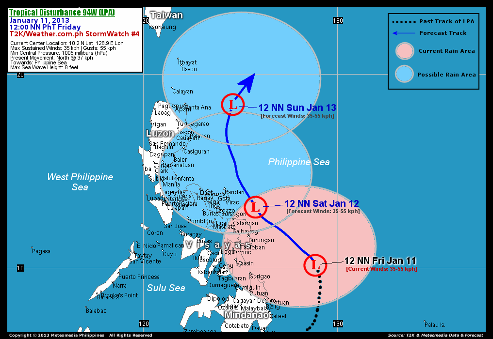
TROPICAL DISTURBANCE 94W (LPA) as of 1:00pm
TROPICAL DISTURBANCE 94W (LPA)

Tropical Disturbance 94W (LPA) becoming better organized...moving quickly northward across the Philippine Sea. Rainbands continues to affect Eastern Visayas, Northeastern Mindanao.
This disturbance will continue to enhance the Northeast Monsoon (Amihan) and bring 15-35 km/hr winds with "on-and-off" slight, moderate to sometimes heavy rains across Bicol Region, Northern Visayas, Southern and Eastern Luzon including Metro Manila today.
Residents and visitors along Visayas, Bicol Region and Eastern Luzon should closely monitor the development of 94W (LPA).
Thursday, January 10, 2013
As of 10:30pm, Jan 10,2013 - Low Pressure Area (LPA

As of 10:30pm, Jan 10,2013 - Low Pressure Area (LPA) - ay Northward na ang Direksyon nito na posibleng Maglandfall na sa bandang Northern tip ng Surigao or Dinagat island at Samar....,at ayon sa JMA ng Japan ay Tropical Depression na naman ito.... at ang isang pang LPA ay nalusaw na.... Mas malamig na panahon asahan pa sa mga susunod na mga araw dahil sa malakas na hanging AMIHAN..." |
Sunday, January 6, 2013
Tropical Disturbance 94W afftecting Gen. Santos this afternoon, today


As of 4pm, SUNDAY - "Medyo na Disorganized ang sirkulasyon ng LPA subalit may posibilidad pa itong lumakas at maging Bagyong "BISING" within next few days...., samantala ang Kaulapan sa Marshall island ay may posibilidad pang maging LPA ito sa loob ng 24 oras...at mas magiging maulan po lalo na mamayang gabi at bukas(monday) sa Mindanao area."
Saturday, January 5, 2013
Possible Storm coming for the next few day

As of 9pm, Sat. - Bagyong BISING at BAGYONG CRISING ??? - may Low Pressure Area(LPA) tayong binabantayan hanggang ngayon na posibleng maging Bayong "BISING"...., at isa pang kaulapan na posible namang maging LPA at maging Bagyong "CRISING" within next 3-5 days.... - MINDANAO area naman ang target(Landfall target) ng dalawang weather Disturbance na'to..... STAY TUNED FOR MORE UPDATES. |
Thursday, January 3, 2013

Tropical Depression Auring as of 5pm


| ||||||||||||||
| ||||||||||||||
| ||||||||||||||
Tropical Depression "AURING" as of 6pm

As of 6pm, Jan 3,2013 - Tropical Depression "AURING"
- Halos naglandfall na sa Southern Palawan at asahan bukas na lalabas na ito agad ng PAR.......
Strength - 55kph............Movement - West @28kph
Signal no. 1 - Palawan
Tropical Depression Auring as of 11am

| ||||||||||||||
| ||||||||||||||
| ||||||||||||||
Wednesday, January 2, 2013
OCD weather advisory (1-2-2012 5pm)

Weather Advisory | via DOST-Pagasa | 2 January 2013 (Wednesday) as of 1700 hours – A the Low Pressure Area (LPA) was estimated at 440 KM East of Mindanao (6.0°N, 130.5°E) embedded along the Intertropical Convergence Zone (ITCZ) affecting Visayas and Mindanao. Northeast Monsoon affecting Northern Luzon.
Eastern Mindanao particularly Davao Oriental and Compostela Valley will be cloudy experience moderate to heavy rains from 5.0 - 15.00 mm/hr. Coastal waters East of Mindanao will be moderate to rough, including the Eastern seaboard from Batanes, Southeastern Luzon, Eastern Visayas to Northeastern Mindanao as a result of the Northeastern Monsoon (Amihan). Please take necessary precaution and all DRRMCs in affected areas to remain on HIGH ALERT status for any eventualities. |

As of 9pm, Jan 2,2013 LPA

|
Subscribe to:
Comments (Atom)