


for Wednesday, 20 February 2013 [8:08 AM PhT]
WEATHER.COM.PH TROPICAL CYCLONE UPDATES
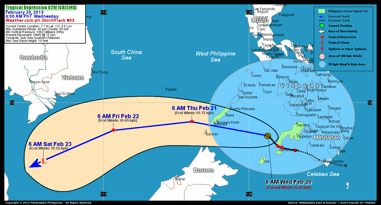
TROPICAL DEPRESSION 02W (CRISING) UPDATE NUMBER 003
Issued: 7:00 AM PhT (23:00 GMT) Wednesday 20 Feb 2013
Next Update: 1:00 PM PhT (05:00 GMT) Wednesday 20 Feb 2013
Tropical Depression 02W (Crising) has slowed down as it emerges of the Sulu Sea. Its disorganized rainbands continues to spread across Mindanao, Visayas and Palawan - bringing occasionally moderate to heavy rains w/ a high threat of flashfloods and landslides.
This depression will continue to enhance the Northeast Monsoon (Hanging Amihan) and bring cloudy skies w/ 15-55 km/hr winds across Luzon including Metro Manila, Mindoro, Marinduque, and Romblon today. Some drizzles to slight rains are expected along Bicol Peninsula including Masbate.
Do not use this for life or death decision. This update is intended for additional information purposes only. Kindly refer to your national weather agency for official warnings, advisories or bulletins.
CURRENT STORM ANALYSIS
As of 6 am today, the center of Tropical Depression 02W (Crising) was located over the Sulu Sea...about 125 km northwest of Zamboanga City or 422 km east-southeast of Bataraza, Palawan...currently moving northwest to west-northwest with a decreased forward speed of 15 km/hr in the general direction of Southern Palawan.
Maximum Sustained Winds (1-min. avg) remains at 45 km/hr near the center with higher gusts. A number of WeatherPhilippines/Meteomedia Automated Weather Stations (AWS) across Mindanao & Visayas continues to register 10 to 130 millimeters (mm) of rainfall in a span of 24 hours, which is considered heavy to extreme. The 24-hour rainfall accumulation near the center of 02W (Crising) is estimated to be heavy (290 mm).
3-DAY FORECAST OUTLOOK*
TD 02W (Crising) is expected to move west-northwest during the next 24 hours, with a turn to the west and west-southwest through the next 2 to 3 days. On the forecast track, the core of 02W (Crising) will move across the Sulu Sea this morning...and will pass over the southern tip of Palawan this evening. The depression should be moving out of the Philippine Area of Responsibility (PAR) on Thursday afternoon...and could be just along the South China Sea on Friday and Saturday.
02W (Crising) is forecast to slightly intensify through the next 24 hours reaching a peak of 55 km/hr, before weakening back to 45 km/hr on Friday. By Saturday, 02W will dissipate into an area of low pressure.
The following is the summary of the 3-day forecast outlook on this system:
 THURSDAY MORNING: Moving away from the southern coast of Palawan as it slightly intensifies...about 165 km west of Bataraza, Palawan [6AM FEB 21: 8.7N 116.1E @ 55kph]. FRIDAY MORNING: Weakens as it moves out of the PAR...about 484 km south-southeast of Nha Trang City, Vietnam [6AM FEB 22: 8.1N 110.7E @ 45kph]. SATURDAY MORNING: Dissipating over the South China Sea, just an area of low pressure...about 541 km south-southwest of Ho Chi Minh City, Vietnam [6AM FEB 23: 6.0N 105.9E @ 35kph].
 *Please be reminded that the Forecast Outlook changes every 6 hours, and the Day 3 Forecast Track have an average error of 250 km...while the wind speed forecast error, averages 35 kph per day. Therefore, a turn to the left or right of its future track and changes in its wind speed must be anticipated from time to time.
EFFECTS & HAZARDS SUMMARY
Below is the summary of the storm's parts and its hazards affecting specific areas. You can also view this image link for you to understand the parts.
RAINBANDS - spreading across Southern Philippines, Moro Gulf, & Sulu Sea. Affected Areas: Mindanao, Visayas, & Palawan.Tropical Disturbance Conditions with light, moderate to strong winds (05-55 kph) will be expected along these bands (click here to know more about Rainbands). 24HR TOTAL RAINFALL ACCUMULATION - from 5 up to 100 mm (slight to heavy rainfall) can be expected along areas affected by the rainbands (see above)...with isolated amounts of 101 to 290 mm (heavy) along areas to the north and near the center of 02W (Crising).
Important Note: Please keep in mind that the above forecast outlook, effects and hazards summary changes every 6 to 12 hrs!
No comments:
Post a Comment